//ads start// //ads end// ಸುತ್ತೋಣ ಬನ್ನಿ - Sutthona Banni: CHITRADURGA

///ad links google adsence


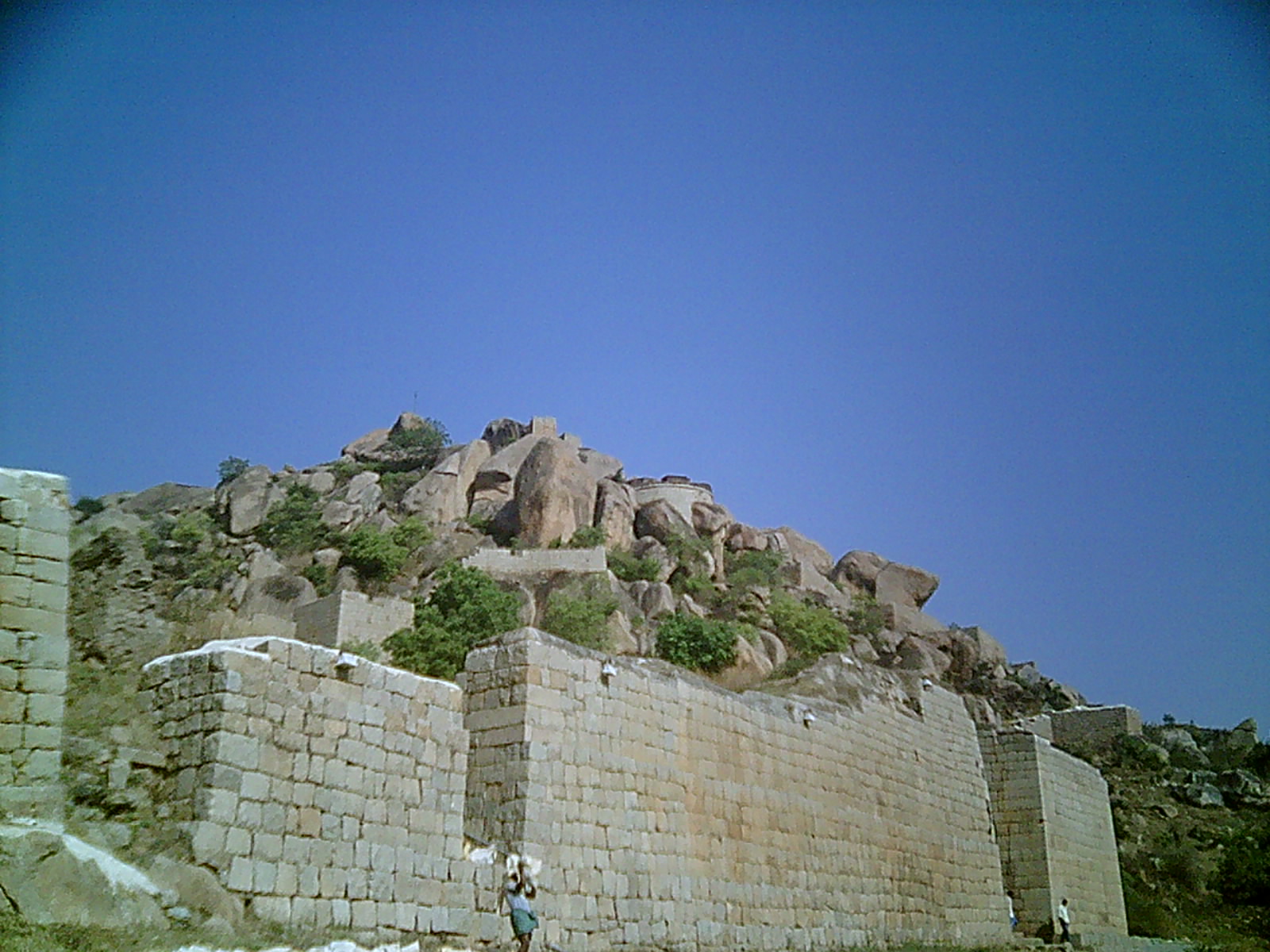
Chitradurga Fort (Kannada: ಚಿತ್ರದುರ್ಗದ ಕೋಟೆ), or as the British called it Chitaldoorg, straddles several hills and a peak overlooking a flat valley in the Chitradurga District, Karnataka, India. The fort's name Chitrakaldurga, which means 'picturesque fort' in Kannada, is the namesake of the town Chitradurga and its administrative district.[1][2][3][4]

The Fort was built in stages between the tenth and eighteenth centuries by the dynastic rulers of the region, including the Rashtrakutas, Chalukyas and Hoysalas as well as the Nayakas of Chitradurga, feudal lords in the Vijayanagar Empire. The Nayakas of Chitradurga, or Palegar Nayakas, were most responsible for the expansion of the fort between the 15th century and 18th century. They were defeated by Hyder Ali at Chitradurga in 1779 AD. Later the fort was expanded and strengthened by Hyder Ali and his son Tippu Sultan,who succeeded Madakari Nayaka V, the last ruler of the Nayaka clan. The fort is built in a series of seven concentric fortification walls with various passages, a citadel, masjid, warehouses for grains and oil, water reservoirs and ancient temples. There are 18 temples in the upper fort and one huge temple in the lower fort. Among these temples the oldest and most interesting is the Hidimbeshwara temple. The masjid was an addition during Hyder Ali’s rule. The fort's many interconnecting tanks were used to harvest rain water, and the fort was said to never suffer from a water shortage.


Etymology

Chitradurga is formed of two words in the Kannada language: ‘chitra’ means “picture” and ‘durga’ means “fort” and is tagged with the English word ‘Fort’ to form the name “Chitradurga Fort”. It is also locally known as “Kallina Kote” or Stone Fortress, which is also formed of two Kannada words ‘Kallina’: “Stone” and Kote:“Fort”. Other names used in Kannada are ‘Ukkina Kote”: “Steel Fort” (euphemistically used to mean an impregnable fort) and ‘Yelusuttina Kote’: “Seven circles fort”.

History

Between 1500 AD and 1800 AD, Chitradurga Fort witnessed a turbulent history starting with the Vijayanagar Empire; Vijayanagar Empire had got control of this region from the Hoysalas. Vijaynagar rulers brought the Nayakas, the traditional local chieftains of the area under their control as their feudatory, till their dynastic reign ended in 1565 A.D. Thereafter, the Nayakas of Chitradurga took independent control of the region and their clan ruled for more than 200 years untill the last of their rulers Madakari Nayaka V was defeated by Hyder Ali of Mysore Kingdom, in 1779. During all these years, Chitradurga Fort was central to the reign, particularly of the Nayakas.

Timmana Nayaka or Thimmappa Nayaka, a chieftain from Matti in Davangere taluk, during the rule of Saluva Narasimha, was the first ruler in the hierarchy of the Nayakas of Chitradurga. Initially, he was a chieftain under the Vijayanagar Empire but was soon elevated to the rank of Governor of Chitradurga by the Vijayanagar ruler in recognition of his excellent provence in military service to the empire. His rule covered areas of the Davangere district and Chitradurga district. His rule lasted for a brief period and ended with his incarceration and death in the jail of the Vijaynagar Empire. After him, his son Obana Nayaka or Madakari Nayaka (1588–1602) succeeded him. Madakari Nayaka was followed by a series of hierarchical or other adopted forms of successions of the same clan; Madakari Nayaka V was the final ruler of the clan from 1758 to 1779. Bharamappa Nayaka who ruled from 1689 till 1722 is regarded as the greatest of the Nayaka rulers famed for building forts, palaces, tanks and temples, including several gateways and bastions. He fought several battles against the Mughals

However, it was during the reign of Madakari Nayaka V (1758 to 1779) that the city of Chitradurga and the Fort were besieged by the troops of Hyder Ali. Madakari Nayaka used the fort effectively for defense during three battles that were fought against Hyder Ali. At times he had allied himself with Hyder Ali of Mysore Kingdom and at other times with the Marathas. Hyder Ali attacked the Chitradurga Fort first time in 1760, the second time in 1770 and the third time successfully in 1779 when he defeated Madakari Nayaka. Madakari Nayaka was taken a prisoner and killed. Nayaka's gamble of playing with both Hyder Ali and the Marathas did not work out. He was betrayed by the Marathas and some local Muhammadan officers in his service. Subsequent to his death the treasury at the fort is said to have yielded a rich bounty. It was during one such war that the heroics of Onake Obavva, the wife of a soldier guarding the fort became a legendary event.

The dynastic reign of the Nayakas lasted for over 200 years and the Chitradurga fort was their stronghold and the very heart of their province.

In the Fourth Mysore War, Tippu Sultan was killed by the British in 1799, and the Mysore Kingdom was reordered under the Wodeyars. Chitradurga became a part of Mysore province. The British considered Chitradurga Fort as a potentially useful base for providing a strong line of defense to Mysore's northern border. Between 1799 and 1809, the British garrisoned their troops in the fort. Later, the control of the fort was restored to the Government of Mysore.

Brave woman

Heroic deeds of a woman named Obavva, wife of a soldier called Kalanayak was guarding a fort tower, substituting for her husband during a lunch break. She was guarding the Chitradurga Fort at a crack opening, a secret opening (where only one person could barely squeeze through). Her heroics at this location have entered the annals of legendary folklore of the Karnataka State. While fetching water, she heard the muted sounds of enemy soldiers attempting to enter the fort through the crevice. With great presence of mind she immediately hid behind the crevice in the fort and hit at each soldier trying to squeeze through the crevice with Onake, the name given in Kannada to a masse or pestle, a wooden rod used for pounding paddy. In this process, she bravely killed several enemy soldiers. By the time her husband appeared on the scene, she had already dragged several bodies of dead soldiers into the fort wall and was standing around the dead bodies with the blood stained Onake in her hand. Kalanayak blew the bugle when other soldiers also joined him and killed all the enemy soldiers. This brave act saved the fort on that day from further attacks by Hyder Ali’s soldiers. Her heroic act has been commemorated with her impressive statue (sculpted by Ashok Gudigar) erected in front of the District Commissioner’s office in Chittradurga town. The stadium in the town has also been named after her. This act also earned her the epithet Onake Obavva and the crevice in the fort where she showed her bravery is called Onake Kindi. However, in the battle for the fort, Madakari Nayaka V lost and Chitradurga fort eventually fell to Hyder Ali, in 1779.

Photo Gallery:


Photos: Sudeepa.N-Chitradurga
Information Courtesy: Wikipedia


Vani Vilasa Sagara (Mari Kanive) (Kannada: ಮಾರಿ ಕಣಿವೆ) is a dam near Hiriyur Taluk, Chitradurga District, in the Indian state of Karnataka. It is the oldest dam in the state.

The dam was built by the Mysore Maharajas pre-independence across the river Vedavathi. The dam is an exquisite piece of architecture, an engineering marvel for that time, and provides water to lots of surrounding cities, towns and villages, which are largely dry lands of the Deccan area of Central Karnataka.


Significance

This dam is the source of domestic water for Hiriyur and Chitradurga. It irrigates more than 100 km² of land in Hiriyur and Challakere taluks through right and left bank canals. This place is 160 km from Bangalore on the NH-4 highway and 40 km from Chitradurga.

History

The dam was constructed by a team led by an Engineer called 'Tara Chand Dalal' at the order of his Highness the Maharaja of Mysore Sri Krishnaraja Wodeyar IV.

Tourism

The dam has been a tourist attraction for many years, but has been apparently neglected as a prime tourist destination. Recently, though, the development work undertaken by the forest department to restore the nearby forest cover, and the 'panchavati' gardens - a garden of medicinal plants with the old Indian cultural theme has improved the tourist figures, making it a popular weekend picnic spot. The 'panchavati' garden has medicinal plants lined up representing cultural themes - the 'Rashis', 'Sapta swaras', 'Nava grahas' and many more. The tourists who visit Chitradurga and Hosdurga often visit Mari kanive on the way. The historic maarikaamba temple here also attracts many tourists. The place is around 20 km drive from Hiriyur on a deviation from NH4 (Bangalore - Mumbai National Highway).

Photo Gallery:


Photos: Sudeepa.N-Chitradurga
Information Courtesy: Wikipedia


Chandravalli is an archaeological site located in the Chitradurga district of the state of Karnataka, India.The region is a valley formed by three hills, Chitradurga, Kirabanakallu and Cholagudda.It is a semi-arid region with scrub vegetation with a stream running through it. Excavations at Chandravalli have revealed earthen pots, painted bowls and coins of Indian dynasties like Vijayanagar, Satavahana and Hoysalas as well as denarii of Roman emperor Augustus Caesar and a coin of the Chinese Han dynasty Emperor Wu Ti belonging to 2nd Century B.C.

Excavation history

Chandravalli was first excavated by R. Narasimhachar who was the Director of Department of Archaeology and Museums of the Mysore state. Further excavations were carried out by H. M. Krishna in 1928-29 and finally by Mortimer Wheeler under the guidance of the Archaeological Survey of India in 1947.


Findings

Two distinct periods; megalithic and Satavahana were noticed during the excavations. It was found that Chandravalli was inhabited from Iron Age onwards. The inscriptions found in the nearby hillocks belonged to the Chalukya and Hoysala period, with one belonging to the king Mayurasharma, the founder of the Kadamba dynasty.

Photo Gallery:


Photos: Sudeepa.N-Chitradurga
Information Courtesy: Wikipedia


The first Murugha Rajendra Mutha at Chitradurga was built on the Chinmuladri hills by Palegar Bichugatti Bharamanna Nayaka. Later it was shifted to the present muth in 1703 AD which is situated at the left side of Chitradurga-Davanagere road near M.K.Hatti.
Now the 27th Pontiff of the order Sri Shivamurthy Murugha Rajendra Sharanaru prerides over the Muth.
The Murugha Vana in the premises of the muth is a beautiful botanical garden.

Photo Gallery:


Photos & Information: Sudeepa.N-Chitradurga


Chitradurga district (Kannada: ಚಿತ್ರದುರ್ಗ ) is an administrative district of Karnataka state in southern India. The city of Chitradurga is the district headquarters. Chitradurga gets its name from Chitrakaldurga, an umbrella-shaped lofty hill found there. Tradition dates Chitradurga District to the period of the Ramayana and Mahabharata. The whole district lies in the valley of the Vedavati River, with the Tungabhadra River flowing in the northwest. During the British times it was named Chitaldroog. The district was practically ruled by all the well known dynasties that ruled Karnataka.

Geography

The district is hilly, with lots of forts and villages. The district is bounded by Tumkur District to the southeast and south, Chikmagalur District to the southwest, Davanagere District to the west, Bellary District to the north, and Anantapur District of Andhra Pradesh state to the east. Davanagere District was formerly part of Chitradurga. The district is divided into taluks, namely Chitradurga, Hiriyur, Hosadurga, Holalkere, Challakere and Molakalmuru. It is rich in mineral deposits, including gold prospecting at Halekal, Kotemardi or Bedimaradi, etc., and open cast copper mines at Ingaldhal.


History and Legends

Chitradurga features bold rock hills and picturesque valleys, huge towering boulders in unimaginable shapes. It is known as the "stone fortress" (Kallina Kote). The landscape looks much like a mischievous giant's playground, with boulders thrown around, forming silhouettes against the sky. According to a story in the Epic Mahabharatha, a man-eating giant named Hidimbasura lived on the Chitradurga hill and was a source of terror to everyone around. When the Pandavas came with their mother Kunti in the course of their exile, Bhima had a duel with Hidimba. Hidimba was slain by Bhima and peace returned to the area. Legend has it the boulders were part of the arsenal used during that duel. In fact, the boulders on which major part of the city rests belong to the oldest rock formation in the country.

Timmana Nayaka a chieften under the Vijayanagar empire rose to the rank of governor of Chitradurga as a reward for his excellence in military achievements, from the Vijayanagara ruler. This was the beginning of the rule of the Nayakas of Chitradurga. His son Obana Nayaka is known by the name Madakari Nayaka 1588 CE. Madakari Nayaka's son Kasturi Rangappa 1602 succeeded him and consolidated the kingdom to rule peacefully. As he had no heirs to succeed him, his adopted son, the apparent heir was enthroned but was killed in few months by the Dalavayis.

Chikkanna Nayaka 1676, the brother of Madakari Nayaka II sat on the throne, and his brother succeeded him with the title Madakari Nayaka III in 1686. The unwillingness of Dalawayis to accept Madakari Nayaka III's rule gave an opportunity to one of their distant relatives, Bharamappa Nayaka to ascend the throne in 1689. He is known as dthe greatest of the Nayaka rulers. Somehow, the subjects of Chitradurga did not experience a good reign of the successive rulers as they ruled on the throne for very brief periods. The Hiri Madakari Nayaka IV 1721, Kasturi Rangappa Nayaka II 1748, Madakari Nayaka V 1758 ruled this area but there is not much to mention of their rule.

Battle with Hyder Ali, Legend of Obavva

During the reign of Madakari Nayaka, the city of Chitradurga was besieged by the troops of Hyder Ali. A chance sighting of a woman entering the Chitradurga fort through an opening in the rocks led to a clever plan by Hyder Ali to send his soldiers through the hole. The guard on duty near that hole had gone home for lunch and asked his wife to be on guard until he was back. The wife of that guard, Obavva while in her temporary seat, noticed soldiers emerging out of this opening. Obavva was not perturbed. She was carrying with her an Onake (a long wooden club meant for pounding paddy grains). She killed Hyder Ali's soldiers one by one as they attempted to enter the fort through the opening and quietly moved the dead. Over a short period of time hundreds of soldiers entered and fell, without raising any suspicion. Obavva's husband, upon his return from his lunch was shocked to see Obavva standing with a blood stained Onake and hundreds of dead bodies of the enemy around her. The opening in the rocks still remains as a historical witness for the story, beside the Tanniru doni a small water source which holds cold water all round the year. Though her sincere and brave attempt saved the fort on that occasion, Madakari Nayaka could not repel Hyder Ali's attack in 1779. In the ensuing battle, the fort of Chitradurga was lost to Hyder Ali. Obavva, like Kittur Rani Chennamma remains a legend, especially to the woman of Karnataka.

The Fort (ಏಳು ಸುತ್ತಿನ ಕೋಟೆ )

Chitradurga Fort is renowned for its name Kallina Kote / Ukinna kote / Elu Suttina kote in Kannada, which was built in parts by the Palegar Nayakas, Hyder Ali and Tipu Sultan. It comprises a series of seven enclosure walls. Eighteen ancient temples can be found inside the fort. This seemingly impregnable fort has 19 gateways, 38 posterior entrances, a palace, a mosque, granaries, oil pits, four secret entrances and water tanks. The rulers of this fort built 2000 watch towers to guard and have a better look at enemies movement all the time.

Location

Accessible by road, this fortress lies on the outskirts of what is Chitradurga today. City of Chitradurga is located at the junction of NH-4 (Bangalore-Pune National Highway) and NH-13 (Sollapur-Mangalore National Highway). Chitradurga is also accessible by train. There is a daily service to Bangalore and weekly services to Mumbai. Proposed link between Chitradurga and Tumkur can reduce the travel time to Bangalore by half.

Places to Visit

Taralabalu Mata Sirigere Sirigere place from towards Chitradurga to Davanagere. Sirigere is situated on the Poona- Bangalore National Highway (NH4). It is at distance of 227 KM from Bangalore and is located between Chitradurga (27 KM), the District Head Quarters, and Davangere (50 KM). It can be easily recognized while travelling on the National Highway No.4 by the presence of an attractive arch on the western side. Sirigere is just 6 KM from this Arch.

Chitradurga Kote is a fort that is one of a kind, as it is built on top of hill with stones. Chitra-durg gets its name because of this fort. "Chitra durga" means "picture perfect".

Ashoka Siddapura is an important archaeological site where emperor Ashoka's edits were found. Nearby is Ramagiri, a hillock that has mythical associations with the epic Ramayana. A temple dedicated to Rameshwara built in 926 CE. exists here.

Brahmagiri village is the ancient site of Ishila, one of emperor Ashoka's provincial capitals. His earliest rock edicts in Brahmi script and Prakrit language (3rd c. BC) containing Kannada words were discovered here.

Chandravalli is an ancient archaeological site where painted pottery and coins from the Shatavahana empire and prehistoric times were discovered. The rock inscription of king Mayurasharma dated 450CE. discovered here gave historians much information about Karnataka's first Kannada kingdom.

Hiriyur situated on the right bank of Vedavathi river is famous for its Therumalleshawara temple. The temple has impressive lofty gopura and the ceiling of the main hall is painted with scenes from the Shivapurana and Ramayana.

Jogimatti Hill Station

Molakalmuru fortified town of the Kadambas

Neerthadi is famous for its Ranganathaswamy temple built in Vijayanagar style.

Vani Vilas Sagar (also known as Mari Kanive) an artificial lake built by the Mysore Maharaja across the river Vedavathi. The reservoir has two mantapas built in saracenic style.

Thamatekallu has ancient rock inscription and the oldest virgallu or hero stone inscription in Karnataka.

Holalkere is well known for its 10th century Jain settlement and 9 ft. tall statue of Bala Ganapathi, a child form of Hindu god Ganapathi.

Doddahottrangappa Hill has a Ranganathaswamy temple on top of a hillock which is a trekkers paradise.

Halu Rameshwara near Hosadurga is well known for the temple & wells, the well has white coloured water (looks like milk) in it that's why the name 'Halu' Rameshwara.

Harthikote a historical (Palegar's of Madakarinayaka ruled) village of Hiriyur taluk, Famous for 'Dana Jathra'. conducting every year in month of April. Veerabhadreshwara, Revanna Siddeshwara temples are famous here.

Photos: Sudeepa.N-Chitradurga

Information Courtesy: Wikipedia