//ads start// //ads end// ಸುತ್ತೋಣ ಬನ್ನಿ - Sutthona Banni: KERALA

///ad links google adsence


Kerala (Malayalam: കേരള / കേരളം) is an Indian state located on the Malabar coast of south-west India. It was formed on 1 November 1956 by the States Reorganisation Act by combining various Malayalam-speaking regions.The name Kerala takes the form Keralam in Malayalam, the main language of the state.

The state has an area of 38,863 km2 (15,005 sq mi) and a population of 3.33 crore (33.3 million). It is bordered by Karnataka to the north and north-east, Tamil Nadu to the east and south, and the Arabian Sea to the west. Thiruvananthapuram is the state capital; other major cities are Kochi (Cochin) and Kozhikode (Calicut).

The Chera Dynasty was the first powerful kingdom based in Kerala, though it frequently struggled against attacks by the neighboring Cholas and Pandyas. During the Chera period Kerala became an international spice trading center. Later, in the 15th century, the lucrative spice trade attracted Portuguese traders to Kerala, and eventually paved the way for the European colonization of the whole of India.

Kerala is an important international and internal tourist destination: the backwaters, beaches, Ayurvedic tourism, and tropical greenery are among its major attractions. National Geographic's Traveler magazine named Kerala as one of the "ten paradises of the world" and "50 must-see destinations of a lifetime"; Travel + Leisure listed it as "one of the 100 great trips for the 21st century".

Subdivisions

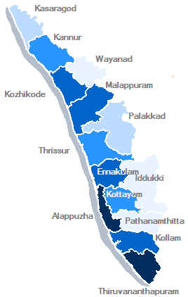
Kerala's fourteen districts are distributed among Kerala's six historical regions: North Malabar (far-north Kerala), South Malabar (northern Kerala), Kochi (central Kerala), Northern Travancore, Central Travancore (southern Kerala) and Southern Travancore (far-south Kerala).

Transport


Roads

Kerala has 145,704 kilometres (90,536 mi) of roads (4.2% of India's total). This translates to about 4.62 kilometres (2.87 mi) of road per thousand population, compared to an average of 2.59 kilometres (1.61 mi) in all India. Virtually all of Kerala's villages are connected by road.
Roads in Kerala include 1,524 km of national highway (2.6% of the nation's total), 4341.6 km of state highway and 18900 km of district roads. Most of Kerala's west coast is accessible through two national highways, NH 47 and NH 17, and the eastern side is accessible through various State Highways. There is also a Hill Highway (Kerala) proposed, to make easy access to eastern hills.
NH 17 connects Edapally (Kochi) to Panvel (Maharashtra) and is the longest stretch of national highway in the state (421 km) Starting from the city of Kochi it passes through Kozhikode, Kannur and Kasaragod before entering Karnataka state. The other major stretch of national highway in the state is National Highway 47, which connects Salem to Kanyakumari and passes through the major towns and cities like Palakkad, Thrissur, Kochi, Alappuzha, Kollam and Thiruvananthapuram. The Salem-Kochi stretch of this highway is a part of North-South Corridor of the Indian highway system. The length of the National Highway 47 (India) through Kerala is 416.8 km.[133] NH 49 (Kochi – Dhanushkodi), NH 208 (Kollam – Thirumangalam), NH 212 (Kozhikode – Mysore), NH 213 (Kozhikode – Palakkad), NH 220 (Kollam – Theni) are the other national highways serving the state of Kerala.
The Department of Public Works is responsible for maintaining and expanding the state highways system and major district roads.The Kerala State Transport Project (KSTP), which includes the GIS-based Road Information and Management Project (RIMS), is responsible for maintaining and expanding the state highways in Kerala; it also oversees a few major district roads.
Traffic in Kerala has been growing at a rate of 10–11% every year, resulting in high traffic and pressure on the roads. Kerala's road density is nearly four times the national average, reflecting the state's high population density. Kerala's annual total of road accidents is among the nation's highest. The accidents are mainly the result of the narrow roads and irresponsible driving.

Railways

The Indian Railways' Southern Railway line runs through the state, connecting most major towns and cities except those in the highland districts of Idukki and Wayanad.
Dates of beginning of railway transport in various sections of the state are given below:
Beypore–Tirur (12 March 1861); Shoranur–Ernakulam (1902); Shenkottai–Punalur (26 November 1904);Nilambur-Shoranur (1927); Punalur–Thiruvananthapuram (4 November 1931); Ernakulam–Kottayam (1956); Kottayam–Kollam (1958); Thiruvananthapuram–Kanyakumari (1979); Thrissur–Guruvayur (1994).
The railway network in the state is controlled by three divisions of Southern Railway, namely Trivandrum Railway Division, Palakkad Railway Division and Madurai Railway Division. Thiruvananthapuram Central is the busiest railway station in the state and second busiest in the Southern Railway Zone after Chennai Central. Kerala's major railway stations are Kannur, Kozhikode, Tirur, Shornur Junction, Palakkad Junction, Thrissur, Angamaly For Kalady, Ernakulam Town, Ernakulam Junction, Alappuzha, Kottayam, Tiruvalla, Chengannur, Kayamkulam Junction, Kollam Junction and Thiruvananthapuram Central.

Airports

Kerala has three major international airports, at Thiruvananthapuram, Kochi and Kozhikode. Two more international airports are proposed, at Kannur and Pathanamthitta. The Cochin International Airport is the busiest and largest in the state, and was the first Indian airport to be incorporated as a public limited company; it was funded by nearly 10,000 non-resident Indians from 30 countries. Trivandrum International Airport was the first international airport in an Indian non-metro city.

Inland water transport

Kerala, with numerous backwaters, is one of the few states in India where waterways are successfully used for commercial inland navigation. The transportation is mainly done with country craft and passenger vessels. There are 67 navigable rivers in Kerala. The total length of the inland waterways in the state is 1687 km. The main constraints to the expansion of inland navigation are lack of depth in the waterway caused by silting, lack of maintenance of navigation system and bank protection, accelerated growth of the water hyacinth, lack of modern inland craft terminals, and lack of a cargo handling system. A 205 km canal, National Waterway 3, runs between Kottapuram and Kollam.

Culture

The culture of Kerala is composite and cosmopolitan in nature and it's an integral part of Indian culture. It has been elaborated upon through centuries of contact with neighboring and overseas cultures. However, the geographical insularity of Kerala from the rest of the country has caused to develop a distinctive outlook in every sphere of culture such as lifestyle, art, architecture, language, literature and social institutions. The Malayalam calendar (also known as Kollavarsham), a solar calendar started from 825 CE in Kerala, serves as the official calendar of Kerala and finds common usage in planning agricultural and religious activities.

Dance

Kerala is home to a number of dance and artforms. Dance forms which originated in Kerala are today popular worldwide especially the Kathakali dance form. Some of the most popular dance forms in Kerala are: Kathakali,Theyyam,Thullal,Koodiyattam,Duffmuttu or Aravanmuttu,Margamkali,Kaikottikali or Thiruvathirakali,Thitambu Nritham.

Music

Development of classical music in Kerala is attributed to the contributions it received from the traditional performance arts associated with the temple culture of Kerala. Development of the indigenous classical music form, Sopana Sangeetham, illustrates the rich contribution that temple culture has made to the arts of Kerala.

Elephants

Elephants have been an integral part of culture of Kerala. Kerala is home to the largest domesticated elephant population in India—about 700 Indian elephants, owned by temples as well as individuals. These elephants are mainly employed for the processions and displays associated with festivals celebrated all around the state. About 10,000 festivals are celebrated in the state annually and some animal lovers have sometimes raised concerns regarding the overwork of domesticated elephants. In Malayalam literature, elephants are referred to as the 'sons of the sahya. The elephant is the state animal of Kerala and is featured on the emblem of the Government of Kerala.

Tourism


Kerala is one of the popular tourist destinations in India. Its culture and traditions, coupled with its varied demographics, have made Kerala one of the most popular tourist destinations in the world. National Geographic's Traveller magazine names Kerala as one of the "ten paradises of the world" and "50 must see destinations of a lifetime". Travel and Leisure names Kerala as "One of the 100 great trips for the 21st century". Kerala's beaches, backwaters, mountain ranges and wildlife sanctuaries are the major attractions for both domestic and international tourists. The city of Kochi ranks first in the total number of international and domestic tourists in Kerala.

Until the early 1980s, Kerala was a relatively unknown destination. But in 1986 the government of Kerala declared tourism as an industry and it was the first state in India to do so.Aggressive marketing campaigns launched by the Kerala Tourism Development Corporation, the government agency that oversees tourism prospects of the state, laid the foundation for the growth of the tourism industry. In the decades that followed, Kerala's tourism industry was able to transform the state into one of the niche holiday destinations in India. Many innovative marketing strategies were used and the advertisements branded Kerala with a catchy tagline Kerala, God's Own Country. Today, Kerala tourism is a global brand and regarded as one of the destinations with highest recall. In 2006, Kerala attracted 8.5 million tourist arrivals, an increase of 23.68% over the previous year, making the state one of the fastest-growing destinations in the world. In 2011, tourist inflow to Kerala crossed the 10-million mark.

Kerala has also pioneered health and medical tourism in India and has attained international attention in this segment. Though the idea of health tourism in Kerala is heavily concentrated on Ayurveda, it is also a good destination for other forms of treatment, including allopathy and homeopathy. Ayurvedic tourism became very popular since the 1990s, and private agencies like Kottakkal Arya Vydyasala played a notable role in tandem with the initiatives of Tourism Department. Kerala is known for its ecotourism initiatives and in this segment it promotes mountaineering, trekking and bird-watching programmes in the Western Ghats as the major products.

The state's tourism industry is a major contributor to the state's economy, which is currently growing at a rate of 13.31%. The revenue from tourism increased fivefold between 2001 and 2011 and crossed the INR190 billion mark in 2011. Moreover, the industry provides employment opportunity to 1.2 million people.
The most popular tourist attractions in the state are beaches, backwaters and hill stations. Major beaches are at Kovalam, Varkala, Kappad, Muzhappilangad and Bekal. Popular hill stations are at Munnar, Wayanad, Wagamon, Peermade, Nelliampathi and Ponmudi. Kerala's ecotourism destinations include 12 wildlife sanctuaries and two national parks: Periyar Tiger Reserve, Neyyar Wildlife Sanctuary, Chinnar Wildlife Sanctuary, Thattekad Bird Sanctuary, Wayanad Wildlife Sanctuary, Muthanga Wildlife Sanctuary, and Eravikulam National Park are the most popular among them. The "backwaters" are an extensive network of interlocking rivers (41 west-flowing rivers), lakes, and canals that center around Alleppey, Kumarakom, Kollam and Punnamada (where the annual Nehru Trophy Boat Race is held in August). Cities such as Thiruvananthapuram, Kochi and Kozhikode are popular centres for their shopping and traditional theatrical performances.

Kerala is also a center of heritage and religious tourism sites. Padmanabhapuram Palace and the Mattancherry Palace are two notable heritage sites. The state is also famous for the large number of festivals (about 10,000 per year) it celebrates; of these, Onam and Thrissur Pooram attract a large inflow of foreign tourists. According to a survey conducted among foreign tourists, Elephants, fireworks display and huge crowd are the major attractions of Thrissur Pooram. The main pilgrim tourist spots of Kerala are Sabarimala Temple, Aranmula Temple, Padmanabhaswamy Temple, Guruvayoor Temple, Chettikulangara Temple, Vadakumnathan Temple, Sarkara Devi Temple, Padanilam Parabrahma Temple, Beemapally mosque, Saint Thomas Syro-Malabar Catholic Church, Malayattoor, Parumala Church (Pathanamthitta) and St. Francis Church, Kochi. Saint Alphonsa Syro-Malabar Catholic Church, Bharananganam is also a destination of pilgrimage tourism.


Photo Gallery:


Courtesy: Wikipedia


Siruvani Waterfalls and the dam named after them are located 46 km (29 mi) north of Mannarkad, Palakkad town in the Western Ghats. The reservoir at Siruvani was built for Tamil Nadu by the Kerala Government to meet the drinking water requirements of Coimbatore. The Siruvani falls and dam is situated some 37 kilometers to the west of Coimbatore city in the Western Ghats. 

The gateways on either side of the road across the dam are typical of the Kerala and Tamil architectural styles. Siruvani is also home to certain tribals like the Mudugars and Irulars.. Water from Siruvani River is renowned for its taste and mineral properties, and the view from the falls and the dam is a great tourist attraction.

The falls are 6 km (3.7 mi) from Karunya University. Sadivayal Checkpost, where an entry fee is charged, is the gateway to the waterfalls. Bus lines 59C, 59, 14E, and the Sirvani and Sadivayal buses, ply at regular intervals from Coimbatore. Other interesting projects/places nearby are Parambikulam, Aliyar, Sholiyar, Palar rivers and the Anaimalai Hills range.

The sweetness has been attributed to the vegetation and rocks through which the water flows through in the Attapady area. The Siruvani dam, located in Kerala close to the picturesque Attapady valley, has an interesting history. The Government gave its approval for construction of the `masonry gravity' damin February 1915, work did not start immediately, if we correlate the information from the Archaeology Department, Tamil Nadu Water Supply and Drainage (TWAD) Board and the district gazette. The villagers of Boluvampatti and Alandurai opposed the scheme, as they feared it would affect them. But they were convinced about the benefits of bringing Siruvani water to a town that was growing. Construction finally began in 1927. But it was no easy task, for the dam site was in an extremely unfriendly terrain. Worse, wild animals frequented the place. So, all those engaged in construction work stayed in the guesthouse near Iruttu pallam. They rode their way to the dam site on horses with gunmen providing security. Even now, a visit to the Siruvani dam is not much different (except for the fact that you don't have to travel on a horse). Forest guards continue to accompany those who visit the dam. The initial cost of construction was Rs. 2, 17,725 (for 23 feet). And, the reason for selecting the site - it had perennial streams. The area below the Siruvani, Muthikulam falls, Gobiyaru, Solaiyaru, Pattiyaru, Veeraru and Paambaru falls, the main sources of supply, was identified for construction. There were even plans to commission a hydroelectric project at Siruvani. But the move was dropped as the Pykara project in the Nilgiris was mooted at the time. Major and minor construction works continued till 1984 and the total cost worked out to Rs. 26.12 crores. The drawal from the dam was in 1931 was 113 lakh litres for a population of more than 95,000. All those who complain about inadequate water supply from Siruvani, take heart. Water shortage is nothing new. In the 1970s, the drawal was scaled down to 130 lakh litres from 186 lakh litres in the summer as inflow into the Muthikulam reduced by half.

Photo Gallery:


Photos: Shivaprasad M.A.-Bellary
Information Courtesy: Wikipedia


Soochipara Falls als known as Sentinel Rock Waterfalls is a spectacular three-tiered waterfalls in Vellarimala, Wayanad, surrounded by Deciduous, Wet Evergreen and Tropical Montane (Shola) forests. Locally referred to as Soochipara ("Soochi" meaning "Needle" and "Para" meaning "Rock"), the 15-20 minute drive from Meppadi to Sentinel Rock Waterfalls offers scenic views of some of the best tea estates in Wayanad. The Sentinel Rock Waterfalls is 200 metres (656 feet) and offers a cliff face that is ideal for rock climbing.

Once people reach the parking area, they have to pass through a security check at the entrance where they make sure you don't carry any plastic. It takes 10-15 minutes walk to the water falls and water flow is less during summer, which makes it easy to reach the rocks where water falls.


Photo Gallery:


Photos: Sutthona Banni Team
Information Courtesy: Wikipedia


Edakkal Caves  are two natural caves at a remote location at Edakkal, 25 km from Kalpetta in the Wayanad district of Kerala in India's Western Ghats. They lie 1,200 metres above sea level on Ambukutty Mala, beside an ancient trade route connecting the high mountains of Mysore to the ports of the Malabar coast. Inside the caves are pictorial writings believed to date to at least 5000 BC, from the Neolithic man, indicating the presence of a prehistoric civilization or settlement in this region. The Stone Age carvings of Edakkal are rare and are the only known examples from south India.

Petroglyphs

These are not technically caves, but rather a cleft or rift approximately 96 feet (29 m) by 22 feet (6.7 m), a 30-foot-deep (9.1 m) fissure caused by a piece of rock splitting away from the main body. On one side of the cleft is a rock weighing several tons that covers the cleft to form the 'roof' of the cave. The carvings are of human and animal figures, tools used by humans and of symbols yet to be deciphered, suggesting the presence of a prehistoric settlement.

Petroglyphs (also called rock engravings) are pictogram and logogram images created by removing part of a rock surface by incising, picking, carving, and abrading.

The petroglyphs inside the cave are of at least three types. The oldest may date back to over 8,000 years. Evidences suggest that the Edakkal caves were inhabited several times at different points in history.
The caves were discovered by Fred Fawcett, a police official of the erstwhile Malabar state in 1890 who immediately recognised their anthropological and historical importance. He wrote an article about them, attracting the attention of scholars.

Photo Gallery:


                                Stone age writing

Photos: Sutthona Banni team & Wikipedia
Information Courtesy: Wikipedia


Wayanad District (Malayalam: വയനാട്) in the north-east of Kerala, India, was formed on November 1, 1980 as the 12th district by carving out areas from Kozhikode and Kannur districts. Kalpetta is the district headquarters as well as the only municipal town in the district. The region was known as Mayakshetra (Maya's land) in the earliest records. Mayakshetra evolved into Mayanad and finally to Wayanad. The Folk etymology of the word says it is a combination of Vayal (paddy field) and Naad (land), making it 'The Land of Paddy Fields'. There are many indigenous tribals in this area. It is set high on the majestic Western Ghats with altitudes ranging from 700 to 2100 m.
It is the least populous district in Kerala (out of 14).

Geography

Wayanad district stands on the southern tip of the Deccan plateau and its chief glory is the majestic rugged terrain of the Western Ghats, with lofty ridges interspersed with dense forest, tangled jungles and deep valleys. Quite a large area of the district is covered by forest but the continued and indiscriminate exploitation of the natural resources point towards an imminent environmental crisis.

Mountains

Chembra Peak (2,100 metres (6,890 ft)), Banasura Peak (2,073 metres (6,801 ft)), Brahmagiri (1,608 metres (5,276 ft)) are some of the important mountains in the district.

Rivers

The Kabini River, one of the three east flowing rivers of Kerala, is an important tributary of the Kaveri River. Almost the entire Wayanad district is drained by Kabini and its three tributaries, the Panamaram, Mananthavady, and Kalindy rivers. The Banasura Sagar Dam is built on one of tributaries of the Kabini River.

Climate

The distance from the mean sea level and the amount of forest cover creates a pleasant climate in the region. Generally the year is divided into four seasons; cold weather (December to February) hot weather (March to May) South West monsoon (June to September) and North East monsoon (October to November). During the hot weather the temperature goes up to a maximum of 35 °C (95 °F) and during the cold weather the temperature goes down to 07 °C (45 °F). The greater temperature variation in the last 5–6 years is in the range of 18 °C (64 °F) to 28 °C (82 °F). The average rainfall is 2,500 millimetres (98 in) per year.

Major Towns

Access

The Kozhikode - Mysore National Highway 212 (NH 212) passes through Wayanad district. Wayanad is well connected by road to various parts of Kerala and other neighbouring states. Buses go frequently between important centres like Mysore, Bangalore, Ootty, etc. While travelling from Mysore on NH 212, at a place called Gundlupet the road forks, one goes to Ooty and the other goes to Sultan Bathery, which is a prominent town of Wayanad. Buses are frequently available to Kozhikode, Kannur, Thalassery, Vadakara, Gonikoppal, etc. More than 50% of the traffic in and out of Wayanad passes through NH 212, mainly from Kozhikkode. The nearest railway station is at Kozhikode, 75 km from Kalpetta. Other railway stations near to Wayanad are Thalassery(80 km from Mananthavadi), Kannur(93 km from Mananthavadi) and Mysore(110 km from Mananthavadi & 115 km from Sultan Bathery). Kozhikode International Airport at Karipur is the nearest airport. Kozhikode International Airport is at a distance of 95 km from Kalpetta. Kannur International Airport, under construction at Mattannur is at a distance of 70 km from Mananthavadi.
NH 212 passes through Bandipur National Park and then through the Muthanga Wildlife Sanctuary which is the Kerala-Karnataka state border. The roads are good except for some sections inside the Bandipur Forest.

Ghat Roads

Mainly 5 Ghat roads are used for reaching Wayanad from coastal towns & lower hilly towns of Kerala :
1. From Thalassery : Nedumpoil-Periya Ghat road, which connects Kasargod, Kannur, Thalassery & Kuthuparamba with Wayanad
2. From Kozhikkode: Thamarassery-Lakkidi Ghat road, part of NH 212, which connects Kozhikkode and the rest of Kerala, south of Kozhikkode with Wayanad
3. From Vadakara : Kuttiady-Pakramthalam Ghat road, which connects Thalassery, Mahe, Vadakara, Nadapuram, Kuttiady and Thottilpalam with Wayanad
4. From Iritty : Kottiyoor-Ambayathode-Palchuram-Boys Town Ghat road, which connects lower hilly towns and villages of Kannur and Kasargod districts with Wayanad. The towns are : Panathur, Udayagiri, Cherupuzha, Alakode, Sreekandapuram, Payyavoor, Iritty, Peravoor, Kelakam, Kottiyoor, etc.
5. From Nilambur : Vazhikkadavu-Nadukani Ghat road, which connects Nilambur, Palakkad, Thrissur and Perinthalmanna, with Wayanad.


Places of importance

There are various places of touristic, ecological, religious, and historic importance in the district.
  • Thirunelli Temple is a very old temple on the foothills of Brahmagiri. This temple is dedicated by Brahma to Vishnu in the form of Chatturbhuja. The Thirunelly Temple embodies classical, traditional Kerala architecture. This temple dedicated to Lord Vishnu – the god who maintains life, attracts hordes of devotees especially for performing ancestral rites. The shrine is shielded with 30 granite columns and the ground is paved with huge square pieces of granite. It is believed that a ritual dip in the stream Papanasini, running crystal clear downhill, wash one away of all worldly sins. This temple is often referred to as the Kasi of the south. Puthari (October), Chuttuvilakku (January), Navarathri, Sivarathei and Sree Krishna Jaynthi are the festivals conducted in this temple. Karkidakavavu, offerings to the spirits of the departed are made, in August.
  • Edakkal Caves, 32 km from Kalpetta near Ambalavayal, is famous for its pre-historic carvings and paintings.
  • Muthanga wildlife sanctuary. It is on the way from Mysore to Sulthan Bathery. Wild animals such as bison, elephant, deer, and tiger has been spotted. There are also quite a few wild birds in the sanctuary.
  • The Jain Temple near Koottamunda and the Ananthanatha Swami Temple.
  • Valliyoorkav is a temple of historic and social significance.
  • Pallikunnu Church, 14 km from Kalpetta is a famous Pilgrim centre in north Kerala.
  • Varambatta Mosque is one of the oldest mosque in Wayanad and it's famous for varambata nercha. There are many institutions lead by Varambatta Sunni Jama'ath Committee. A beautiful masjid has been built by Sha'kh Aboobacker Ahmad.
  • Mazhuvannur Maha Siva Kshethram is an ancient Shiva temple near Tharuvana. Karat Siva Temple is a very old temple near Kommayad.
  • Sulthan Bathery is famous for its fort, which was built by Tipu Sultan.
  • The tomb of the king Pazhassi Raja, who fought the British with the help of Kurichiya warriors, is in Mananthavady.
  • Lakkidi, the entry-point to Wayanad on the road from Kozhikode, receives the highest rainfalls in Kerala.
  • Pookode lake is another spot to chill out in Wayanad. You may visit the fresh water aquarium or the children’s park, enjoying boating or even shop for handicraft items and spices at the fresh water Pookat Lake that is wrapped in high hills and gorgeous greens.
  • For the adventurous: Chembra peak, Banasura peak and Brahmagiri peak will provide a tough trek experience.
  • Kuruva Dweep (10 km from Mananthavady) is a unique and fragile delta system on the Kabini River.
  • An important and unusual pilgrim centre for sociologists and educationists is Kanavu a centre for alternative education which help the adivasis (tribals) to adapt to the challenges without losing their cultural moorings.
  • Ananthanatha Swami Temple, (also known as ParswanathaSwamy Jain Temple at Puliyarmala) is a beautiful Jain temple located at Puliyarmala, 6 km from Kalpetta.
    • Pakshipathalam is a very popular trekking spot on the Kerala-Karnataka border.
    • Soochipara, Kanthapara, and Meenmutty are waterfalls in the Meppadi-Ambalavayal region.
    • Thovarimala Ezhuthupara is 5 km from Sulthan Bathery. After a 400 m trekk one can reach Thovarimala Ezhuthupara, where stone age pictorial writing on a rock can be seen.
    • Meenmutty Falls is 29 km from Kalpetta in Wayanad District. It is Kerala's second largest waterfall and the one most unspoiled in its natural setting.
    • HML Tea factory achoor, 10 km from Vythiri.

Photo Gallery:


Photos: Sutthona Banni Team & Wikipedia
Information Courtesy: Wikipedia