//ads start// //ads end// ಸುತ್ತೋಣ ಬನ್ನಿ - Sutthona Banni: water Falls

///ad links google adsence

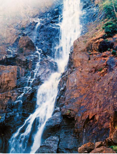
Waatwhalla (Vaatehole Falls) is located approximately 30km from Sirsi town of Uttara Kannada District. A tributary to the Aghanashini river makes this wonder full water falls which is falling from a height of around 120 feet.

"Waate" is the local name of river side bamboo which can be found in plenty here. And "Halla" (in Kannada)  means medium size river. So this falls is called as "Waatehalla Falls".

This falls is located near to one more famous falls -"Unchalli Falls" and sunset point "Bheemana Gudda". 

Route Map:

Public Transport: Take a bus from Sirsi which goes to Heggarani, get down a place by Nilkunda. From here it is 3km walk to the valley, where one has to climb down to reach the waatehalla falls.
Private Transport:  Sirsi --> Ammenalli Cross --> Take left deviation which moves towards Unchalli falls --> Take right deviation near Nilkunda .

Food & Accommodation: 

Near by falls you will not get any thing to eat. So you have to carry food. Nearest food point is Ammenalli (Tea Point) and Sirsi town. For accommodation you have to stay in Sirsi. 

 Photo Gallery:


Waate Plant (River side Bamboo) 


Photos & Information: Shyamsundar Hegde & Gajanan Bhat -Magegar


Mukti Hole (ಮುಕ್ತಿ ಹೊಳೆ) Waterfalls is located in dark and dense green forest of western ghats, which is near to Siddapur town (approx: 31 km from Siddapur) of Uttara Kannada District. Sub-river of Aghanashini river is creating this beautiful waterfalls. This place is unknown to lot of people due to lack of publicity and impassable road connectivity. Journey to this falls is very difficult because you have to trek in dense forest around 4 km in a steep way.
 
Route Map:

Route1: From Siddapur
  •  From Siddapur town, go in Siddapur-Bilagi- Doddamane-Kumta state highway. Around 15 km you will get Bilagi village.
  •  After Bilagi village (approx: 12 km from Bilagi) left side you will get “Kodigadde” cross. Then take a left deviation and reach to Kodigadde village.
  • In Kodigadde village you have to ask with local people about route for Mukti Hole falls.  
  • With the guidance of local people only you can reach to the falls otherwise you will miss the route.
  •  From Kodigadde village you have to trek around 3-4 km in a dense forest. The way to reach the falls is too difficult.    
 Route2: From Honnvar
  • Honnavar --> Hadinabala --> Gundabala --> Kadehalla --> Hirebailu --> Mukti Hole.    
  • But this route is difficult to trek.
Best Time to Visit: From October to January.

   Food Facility: Nearby falls you will not get any food facility. So you have to carry enough food from Siddapur itself.
    Warning: Beware of Leaches and snakes.
    Request: Please don’t throw the food materials, plastics, bottles in the forest area and nearby falls. Keep this place clean and calm and join the hands for “Swacch Bharath Abhiyaan”. Don’t spoil the natural beauty. 

Photo Gallery: 

Photos & Information Courtesy: Gajanan Bhat – Magegar


Uttara Kannada , also known as North Canara or North Kanara, is a district in the southern Indian state of Karnataka. It is bordered by the state of Goa and Belgaum District to the north, Dharwad District and Haveri District to the east, Shimoga District and Udupi District to the south and the Arabian Sea to the west. The town of Karwar is the administrative headquarters of the district. This is also known as “ District of Water falls”. It is heaven for tourists. This district has Coastal areas, Malenadu and Bayaluseeme.

Uttara Kannada District which is not much spoiled yet by commercialization. The District retains its natural beauty to a great extent. The district is having many spots of natural beauty spots in the form of rivers, waterfalls, mountains and beaches.

The Uttara Kannada district is at the North West end of Karnataka State having its share of the natural wonders. Let us have a look at some of the waterfalls, which are not yet known widely by people, of Uttara Kannada District of the Karnataka State in India. The Uttara Kannada district has its share of the nature's bounty in the form of pristine forests, mountains, beaches, rivers and waterfalls. This district may perhaps have the largest number of waterfalls comparing to other districts. Some of the waterfalls are well known and extensively visited by the tourists. There are also many which are not in the beaten track of the usual tourists haunts. Some of them are very tough to approach and requires the stamina and patience.

In Monsoon season visit to water falls of Uttara Kannada and enjoy the beauty of nature.

Note: Don't throw the plastics, bottles, waste materials in the forest and tourist places. Keep the environment clean and calm. Don't spoil the beauty of nature.

List of Water Falls in Uttara Kannada District:
  1. Apsarakonda Falls
  2. Arabile Falls
  3. Benne-Hole Falls
  4. Burude Falls
  5. Devakara (Vajramala) Falls
  6. Hasehalla (Matthi-Ghatta) Falls
  7. Jog Falls (Uttara Kannada-Shivamogga District)
  8. Kumbaal Falls
  9. Lalguli Falls
  10. Magod Falls
  11. Majjige-Hole Falls
  12. Muregar Falls
  13. Negar Falls
  14. Sathoddi Falls
  15. Shirley Falls
  16. Shivaganga Falls
  17. Tumbragodu Falls (Rainy Season only)
  18. Unchalli Falls
  19. Vibhoothi Falls
  20. Watehalla Falls
Photo Gallery:

Apsarakonda Falls
Arabile Falls

 Benne-Hole Falls
Burude Falls
Devakara (Vajramala) Falls
Hasehalla (Matthi-Ghatta) Falls
Jog Falls

 Kumbaal Falls
Lalguli Falls
Magod Falls

 
Majjige-Hole Falls
Muregar Falls
Sathoddi Falls
Shirley Falls
Shivaganga Falls
Tumbragodu Falls

 Unchalli Falls
Vibhoothi Falls

Photos & Information: Wikipedia, Prajavani News Paper, Uttara Kannada district panchayat website, Sutthona Banni Team members


Dabbe falls is one of the must visit places in Shimoga (Shivamogga) district which offers tourists a great pleasure of nature. Dabbe Falls is located near Hosagadde in Sagar taluk. On the road from Sagar to Bhatkal (Kogar Ghat), Hosagadde lies about 20 km from the town of Kargal (Near to Jog Falls). From Hosagadde a walk of 6–8 km into the forest leads to Dabbe Falls.

 The trek route through the deep valley leads to the delightful Dabbe Falls. Trekking to Dabbe falls is very risk as the last 1.5 km trekking is downwards almost 80 degree with no proper stairs. One has to trek using branches and roots of trees and rocks. Last 1.5 km of trekking which consumes lots of time.

Nearby Tourist Places: 

Kanoor Fort, Bhima-Lingeshwara Temple, Sharavathi wildlife Sanctuary, Jog Falls

Route Map:

From Kargal Town--> Go in SAGAR-BHATKAL state highway  towards Bhatkal  up-to Hosagadde  -->   Take Right deviation & go in mud road which is going towards Dabbe Mane up-to 6km (approx)  -->  Then trek for 1.5 km, you will get Dabbe Falls.

Take the help from local people to reach Dabbe falls.

Transport: 

There is no bus till Dabbe falls. KSRTC buses has stop at the main road which is 8 km. Four wheeler can reach 4 more kilometres inside and bike can go up-to 6km. Then you have to trek for 1.5 km to reach till Dabbe falls. 
Note: There is no food facility nearby Dabbe falls, so carry water bottles & food.

Photo Gallery:  


Photos & Information Courtesy: Gajanan Bhat- Magegar